Idaho Paddler's Website: a supplemental resource for users of the book Guide to Idaho Paddling.
Paddling Map Booklets
If you have purchased a copy of the revised edition Guide to Idaho Paddling, we have free downloadable map booklets for you.
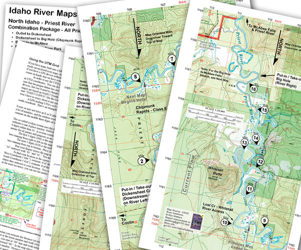
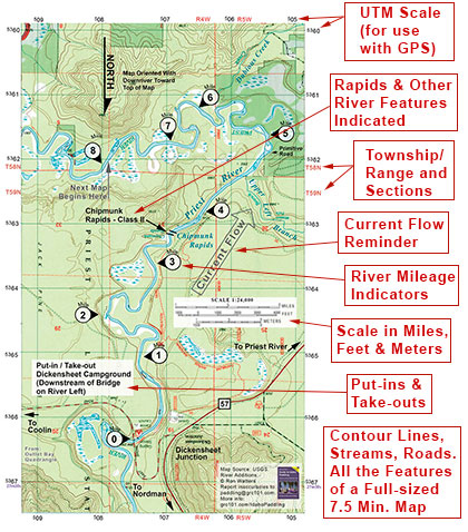
They are high resolution PDF's of detailed river maps created from 7.5 minute USGS maps. Included is a vicinity map (useful for driving to put-in & take-out locations), river notes, and other helpful information.
The maps are legal size and can be printed on a color home printer or at a photocopy/office supply store. All in all, it's an nice package that you can slip in a map case or ziplock bag and take on the river with you. Below is a sample of what they look like.
To access the booklets, you'll need a log-in name and a password. We'll give you that information in a second. First, a quick explanation of the password.
The password is the first word that you find on a designated page in the book plus the following: #656.
For example, if we give you page number 49, the first word on that page is "Thanks." Your password would be Thanks#656. (It is case sensitive so you want to enter a capital "T" first.)
Be sure to check the indicated page number since we change those from time to time
Your log-in name is: GIP
Your password is the first word on page: 106
(Be sure to add #656 after the word)
If you haven't obtained Guide to Idaho Paddling you can purchase the maps for $1.50 for individual maps. Up to $4.50 for the combination packages. To order and pay, go here. (Note, however, that we don't want anyone to go without a map. If you have the first version of Guide to Idaho Paddling - or if you're short of cash - drop us a line at paddling@grc101.com and we'll make sure you can get the map you need.)
Note that the following PDF's are high resolution for printing purposes and are 15 to 30 megabytes in size. You'll need to give it some time to download.
Here are the currently available maps:
Priest River - Outlet to Dickensheet Campground Download Map | More Info
Priest River - Dickensheet to Big Hole (Chipmunk Rapids Stretch) Download Map | Info
Priest River - Big Hole to McAbee Falls Download Map | More Info
Priest River - McAbee Falls to Priest River Park Download Map | More Info
Priest River - All above 4 segments combined into one package Download Map
Moyie River - Copper Campground to Twin Bridges Download Map | More Info
Moyie River - Twin Bridge to Meadow Creek Campground Download Map | More Info
Moyie River - Meadow Creek Campground to Moyie Reservoir Download Map | Info
Moyie River - All above 3 segments combined into one package Download Map