Idaho Paddler's Website: a supplemental resource for users of the book Guide to Idaho Paddling.
North Idaho Rivers
.
 Moyie River
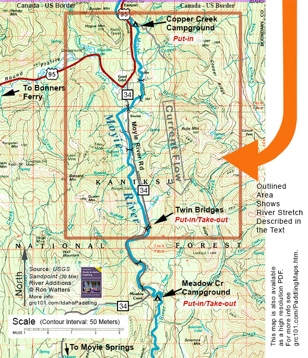
Copper Campground to Twin Bridges
.
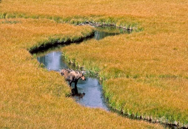
The Moyie is a river of cedar trees. As you paddle downstream, cool breezes drift out of the forest carrying the glorous aroma of a redcedar forest. Granted, the Moyie is not a wilderness river. Roads and railroad tracks run alongside it. Much of the land along the river is private and you'll see homes along the way, but they seem to fade away once on the river and are only minor distractions.
This 10-mile paddle trip on the Moyie is not a pure beginner's run. There are overhanging trees on the outside of bends, snags at the heads of islands, and several mini rapids, some with rolling haystacks. Because of character of the river, we rated as a Class I+ (1.4) in low to moderate water levels. If you're just getting started boating, get some experience first before undertaking this trip, but once you are comfortable manuevering your craft, then this is a beautiful run that you'll want to return to again and again.
Basic Stats
Difficulty: At 1,600 cfs, the river is class I+ (1.4). For information on ratings, go here.
Levels: 500-2,300 cfs at the Moyie River (Eastport) Gage
Distance/Time: 10 Miles / 3-4 hours at 1,500 cfs.
.
 Getting to the Take-out. Twin Bridges. Drive north of Bonners Ferry on US 95. Keep an eye on your odometer and when you are around 29 miles from Bonners Ferry look for a sign indicating the Moyie River Road. The road will be on the right. Turn right on the Moyie River Road (this is also known as Highway 34) and follow it. You'll cross over the Moyie River once, and the second time you cross over the river (at 6 miles from US 95), you'll see a railroad bridge close to the road bridge. This is Twin Bridges. The put-in is on river right, downstream of the road bridge (in other words, you'll be putting in between the two bridges).
Getting to the Put-in. Copper Creek Campground. From the Moyie River Road junction with US 95 (described above), drive towards Eastport (towards the Canadian bordor). At 3 miles from the Moyie River Road junction, you'll cross a bridge. Just on the other side of the bridge, take a right on a side road which is usually well marked with a sign indicating Copper Creek Campground. (If you end up at the Canadian border, you've gone 1 mile too far.) Turn off of US 95 and follow the side road .6 mile to the campground. You'll need to carry boats from the campground down to the river.
Map. The area outlined in orange below is the area covered by this paddle trip. Note that if you have purchased a copy of the book Guide to Idaho Paddling, you can download a free high resolution PDF of this map. It is included in a special map booklet which also includes an annotated and detailed river map of this segment created from 7.5 minute USGS maps. You can download the map booklet here.
 The Trip. The Moyie River Valley could be a scene out of a story book. It is almost seems that at any moment that a character from a Grimms' fairy tale will step out from behind a cedar tree, give you a toothy grin, and wave as you float by. The scenery is exquisite: from the river you have grand vistas of mountains which appear as great green, fur-covered mounds.
As we mentioned, the water is lively and you'll need to watch for overhanding trees and manuever through mini-rapids. At 1,800 cfs, we didn't encountered anything over a class I+ (1.4). The river, however, would be very unforgiving in high flows, and you'll want to wait until the spring and early summer high water season has past before paddling it.
We ran it in an open canoe and thoroughly enjoyed the the lighthearted nature of the river which kept us busy with manuevering here and there. Our friends Gene and Judy Ratcliff were in kayaks and were having a ball, gliding in and out of eddies and playing in small surfing waves.
There are several bridges over the river and they are perfect for keeping track of where you are on the river. (We've included the bridge mileages in the chart below.)
This is an outstanding paddle trip and if you live in the area - or plan to visit - you'll want to make sure it's on your to-do list.
Mileage Chart
0.0 Put-in. Copper Cr. Campground
2.6 Road Bridge ("34D" Bridge)
3.5 Railroad Bridge
4.3 Moyie River Road Bridge
6.5 Earl Lane Road Bridge
10.1 Take-out. Twin Bridges
Shuttle. 10 miles, almost all paved. Good one for a bike shuttle. It is mostly on a paved country road with light to moderate traffic. Three miles are on US 95 which has decent shoulders for riding.
Craft. Kayaks, canoes and inflatables.
Our thanks to our boating and skiing companions Gene Ratcliff and Judy Moyer of Athol.
A Legal Reminder: running rivers is dangerous. It is the reader's responsibility to ensure that they have sufficient skill and fitness to participate in this activity safely. We do not assume liability or responsibility to any person or entity for injuries, death, loss or damages which are caused directly or indirectly by the information contained here.