Idaho Paddler's Website: a supplemental resource for users of the book Guide to Idaho Paddling.
North Idaho Rivers
.
 Priest River
McAbee to Priest River Park
.
The paddle trip from McAbee Falls downriver to it's confluence with the Pend Oreille River has a little of everything: slow, easy going water and an invigorating long stretch of Class III whitewater call Eight Mile Rapid. If you're out for the weekend and are camping, the take-out is conveniently located right next to a developed campground. Or if you're interested in something more primitive, it's even possible to camp on a river beach.
Basic Stats
Difficulty: At 3,000 cfs Eight Mile Rapid is Class III (continuous). Above Eight Mile is some Class I to II-. Below the rapids, the water is quite easy, Class I (1.0 -1.1). For information on ratings, go here.
Levels: 1,200-4,500 cfs at the Priest River gage
Distance/Time: 13.5 Miles / 4-5 hours at 3,000 cfs.
.
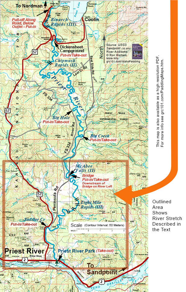
 Getting to the Take-out. Corp of Engineer's Priest River Park. Just on the east side of the town of Priest River on US 2, look for a sign indicating Priest River Recreation Area. Turn off the highway and drive into the park. It's a beautiful park with a beach, camping area and a boat ramp. The take-out is at the boat ramp.
Getting to the Put-in. McAbee Falls Bridge. From the town of Priest River, drive 3.5 miles north on Idaho 57 and turn right onto the Peninsula Road. Follow the Peninsula Road for 4.5 miles until reaching a bridge over the Priest River. The put-in is downstream of the bridge on river left.
Map. The area outlined in orange below is the area covered by this paddle trip. Note that if you have purchased a copy of the book Guide to Idaho Paddling, you can download a free high resolution PDF of this map. It is included in a special map booklet which also includes an annotated and detailed river map of this segment created from 7.5 minute USGS maps. You can download the map booklet here.
 The Trip. When you leave the bridge at McAbee, the river meanders through a large open area. It's predominantly easy-going water in this stretch with homes scattered here and there. At 3.2 miles from the bridge, you'll be approaching the end of the open area and one last set of houses on the right. Here you'll come to the first rapid (I+ to II-).
There's short break after the rapid as you move from the open area into a small forested canyon. By the 3.8 mile point, you'll be at the start of Eight Mile Rapid. The main part of the rapid is 2 to 2.5 miles long. At 3,000 cfs, we stayed largely in the middle, but found that we still had to make moves here and there to avoid curlers and occassional holes which could fill up our open canoe.
By the way, if you are paddlling an open canoe, and you're uncertain of what's ahead, you should slow down. The rapid is continuous and if you flip over, you can swim a long way. Experienced kayakers can paddle straight through this stretch, but a canoeist needs to use extra caution, pulling into eddies or stopping to scout ahead when you can't read the water from your boat.
The rapids at the level we ran it might not be harder than a II+, but because of it's length, class III is a more adequate classification of its difficulty. By the 7 mile point (from the McAbee bridge), the river has settled down, alternating between swift and slow water. In this area, we saw a couple of beaches that would have made nice campsites. If you are planning to camp on the river, however, it's a good idea to make a run the day or two before the camping trip to suss out an adequate spot.
A bit more on river camping: in Idaho, it's legal to camp along the river as long as you are below the high water mark - or on public land that permits camping. (We have an extensive review of the law as it applies to paddlers in an appendix in Guide to Idaho Paddling.) You wouldn't, of course, want to camp in sight of a house, but you're fine as you're below highwater and are out of eyesight and earshoot of the neighbors.
Every so often, you'll encounter some short stretches of swift, wavy water, but the river has largely lost much of its oomph as it meanders it's way to the Pend Oreille River. At around the 10 mile point, Highway 57 comes in view on the right. Not long after the highway comes in view, you'll start down several I+ and minor II- rapids, which are spread out over about a mile and half. It's the river's last kick. From the 12 mile point on, the river gets completely flat.
We ended up on this last quiet stretch as evening approached. It was a pleasing change from the earlier rapid stretch. The river was calm and peaceful with long shadows stretching across the water. Nice homes line the river here with retaining walls and great green lawns blending into one another.
You'll pass under the US Highway 2 bridge and reach Priest River Park. On the left is a dock just before the swimming area (which is maked off by water buoys). The dock is accessble from the camping area if you happen to be camping. Otherwise, continue to paddle just beyond the swimming area where you'll find the boat ramp and the end of the trip.
Shuttle. 8 miles all paved. Bike shuttle possible but it's on a busy highway with a narrow shoulder.
Craft. Kayaks, canoes and inflatables.
Our thanks to our boating and skiing companions Gene Ratcliff and Judy Moyer of Athol.
A Legal Reminder: running rivers is dangerous. It is the reader's responsibility to ensure that they have sufficient skill and fitness to participate in this activity safely. We do not assume liability or responsibility to any person or entity for injuries, death, loss or damages which are caused directly or indirectly by the information contained here.