Idaho Paddler's Website: a supplemental resource for users of the book Guide to Idaho Paddling.
North Idaho Rivers
.
 Moyie River
Twin Bridges to Meadow Cr. Campground
.
The Moyie River here is as beautiful as it is on the upper stretch, but you won't have too much time to enjoy the surroundings. This is a lively piece of water, a step or two more difficult than the upper run on the Moyie described previously. Because of the length of the rapids, we rate this stretch as class III. Any one segment of the whitewater is not more difficult than class II, but when all those parts are combined into the whole, class III is a more appropriate rating.
Basic Stats
Difficulty: At 1,500 cfs, the river is class III. For information on ratings, go here.
Levels: 500-2,300 cfs at the Moyie River (Eastport) Gage
Distance/Time: 5 Miles / 2 hours at 1,500 cfs.
.
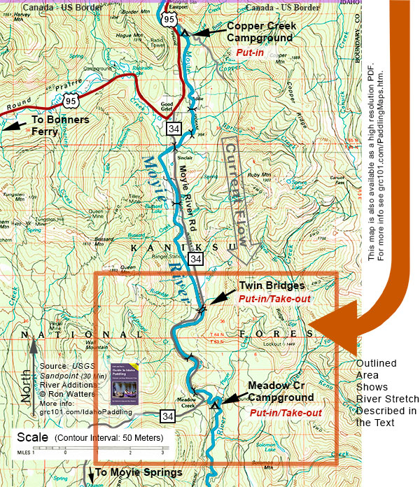
 Getting to the Take-out. Meadow Creek Campground. Drive north of Bonners Ferry on US 95. Keep an eye on your odometer and when you are around 29 miles from Bonners Ferry look for a sign indicating the Moyie River Road. The road will be on the right . Turn here and follow the Moyie River Road (this is also known as Highway 34) for 11 miles until coming to Meadow Creek Campground. The take-out is in the campground. We found a decent eddy for taking out near the Campground Host. We would recommend marking the take-out with some colorful flagging. The river moves through the campground area quickly, and without a marking of some kind, missing the take-out eddy is a distinct possibility.
Getting to the Put-in. Twin Bridges. From the Meadow Creek Campground (described above) head back towards US 95 on the Moyie River Road (Highway 34). Five miles from the campground you'll cross a bridge over the Moyie. Just downstream from the road bridge is a railroad bridge. This is Twin Bridges. The put-in is on river right just downstream from the road bridge.
Map. The area outlined in orange below is the area covered by this paddle trip. Note that if you have purchased a copy of the book Guide to Idaho Paddling, you can download a free high resolution PDF of this map. It is included in a special map booklet which also includes an annotated and detailed river map of this segment created from 7.5 minute USGS maps. You can download the map booklet here.
 The Trip. At the start of this stretch you get a bit of a warm up. The river begins picking up at the first road bridge that you pass under, 2.3 miles from the start. It's just above the next road bridge (Meadow Cr. Bridge) at 3.7 miles where the real action begins.
At 1,500 cfs, the rapid above the bridge begins as a ledge drop. We entered far left of the drop, and ferried back across the base of the drop to the right. Then we turned downstream to break through a big curling wave just before the bridge. That filled up our canoe, and we lumbered down and until catching an eddy on the left below the bridge.
The water continues to move along. At the 4.5 mile point, you'll reach a beautiful area with tilted layers of limestone forming a cliff on river right. We scouted just above the cliff and found a fairly easy path down far right at the base of the cliff.
A couple of hundred yards below the cliff is another small ledge drop signaled by a pipeline crossing just above it. We scouted on the left and eased over the drop on the far right.
From here, there's more lively water to the take-out at the campground. The water moves at a good clip around the campground, and as we mentioned above, it helpful to mark the take-out eddy with some flagging so you don't fly by. (And, of course, once you've gotten off the river be sure to remove the flagging.)
This is a engaging stretch of whitewater. You'll want to take your time, using eddies to pick your way down, and scouting when you can't read the rapids from your boat. That's particularly important for canoeists. With some experience rafters and kayakers can bump on through, but canoeists can easily fill up their boats. If you capsize and come out of your boat, a swim would not be pleasent. If you have an open boat, we recommend scouting the first major drop just before the second bridge and make quick scouts as you continue.
Mileage Chart
0.0 Put-in. Twin Bridges
2.3 First Road Bridge
3.6 Ledge drop & rapid
3.7 Second Road Bridge (Meadow Cr. Bridge)
4.5 Limestone cliff & rapid
4.6 Pipeline crossing & rapid
4.8 Take-out. Meadow Creek Campground
Shuttle. 5 miles. Bike shuttle: gravel road. You'll want a moutain bike.
Craft. Kayaks, canoes and inflatables.
Our thanks to our boating and skiing companions Gene Ratcliff and Judy Moyer of Athol.
A Legal Reminder: running rivers is dangerous. It is the reader's responsibility to ensure that they have sufficient skill and fitness to participate in this activity safely. We do not assume liability or responsibility to any person or entity for injuries, death, loss or damages which are caused directly or indirectly by the information contained here.